rFpro – Images and Videos – London Track
Most Bsimracing visitors will undoubtedly be familiar with the Image Space Incorporated company who are the fathers of the rFactor racing Simulator. The development of the second iteration of the title has recently been taken over by the Dutch developer Studio397.
However, ever since its existence there has also been the lesser known rFpro software. This professional version of the original rFactor was taken over by the British Kangaloosh Limited company who developed it to become a simulator used by automotive OEMs and motorsport manufacturers for engineering development and testing purposes. The software enables manufacturers to perform virtual tests on automotive parts such as chassis, drivetrain and safety systems. Furthermore, rFpro is being used to train, validate and regression-test Deep Learning systems for Advanced driver-assistance systems (ADAS).
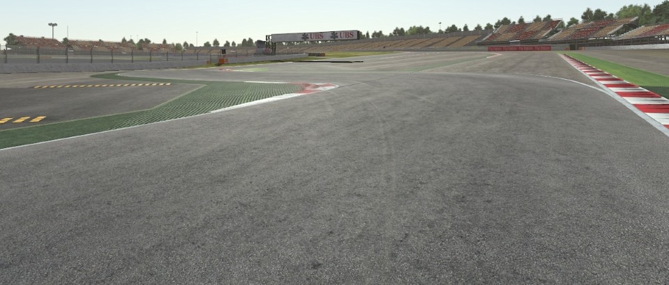
Up Until recently, information and media posts about rFpro were quite scarce. However, in the last few months more and more interesting information and showcase media have surfaced. We could already admire screenshot of the Hungaroring Digital Circuit Model, the Shanghai Public Road Model, and a Digital Model of the center of Paris.
The latest rFpro video shows us footage of a study performed in 2012 to evaluate the feasibility of a London Grand Prix. The video shows us a lap of the suggested route. Look out for Piccadilly, the Wellington Arch, Buckingham Palace and the Victoria Memorial, Parliament Square, Westminster Abbey, Big Ben, the London Eye, Trafalgar Square and a narrow squeeze through Admiralty Arch to the finish on The Mall.
As a bonus, we included an old video showing footage of a 2014 build of the rFpro Nordschleife version.
About rFpro
rFpro originally started as a project within a Formula 1 team to deliver a driving simulator capable of delivering Vehicle Dynamics testing. Since 2007 rFpro has grown to support all the major motorsport categories including F1, NASCAR, WEC, Indy, IMSA, Formula E and Super-GT.
Although predominantly a tool for engineering development, set-up calibration and testing, some of our motorsport customers also make use of rFpro for driver training, particularly for complex steering-wheel controlled on-car systems.
rFpro’s ReplayServer can be setup to record every single test on your simulators, allowing you to replay laps, to compare drivers’ laps side by side, synchronized by distance or time. Recorded laps or data from the offline simulation can be injected into the simulation as Ghost Cars, or as live traffic, to assist with testing of race starts, qualifying hot-laps and with learning new circuits.
Since 2007 rFpro has built Engineering quality and photo-realistic High-Definition (Hi-Def) circuit models from accurate LiDAR surveys. The LiDAR-based track database increases every year and now includes most of the F1 circuits, North American Indy & NASCAR circuits as well as La Sarthe, and the 20km Nordschleife. Public road routes, including specially commissioned OEM test routes, can also be modeled, all with accuracies to within 1cm in x and y and less than 1mm in z.
rFpro has been developing an automated road building pipeline based on the use of kinetic LiDAR (laser scanning) technology since 2008. The starting point for any new road model is a contiguous LiDAR survey with georeferenced spherical photography. Our road building process then runs in the Cloud on rented AWS servers to create the road surfaces and reference material used for the scenery in the completed 3D digital models.
Accurate, high frequency, phase-based LiDAR is used to capture the road and kerb detail that can be critical for vehicle dynamics applications. Longer range Time-of-Flight LiDAR is used to capture the road side furniture and scenery. rFpro’s TerrainServer allows vehicle models to consume very detailed road surface data while remaining real-time. An offline interface also exists for ride and durability studies that have no real-time requirement. Our standard solution represents the road surface as a 1cm grid in x,y, with sub-millimeter accuracy in z. It is possible to order road surfaces at 5mm resolution, however, we must be informed in advance of this requirement as this at the limit of LiDAR beam width resolution.
For more info, check out www.rfpro.com |